Here are some camping options for those travelling on a budget. For paid camping there are two options: Zion River Resort in Virgin, and Watchman campground at the main entrance to Zion National Park (15 miles from the start/finish line.) If you choose the Zion River Resort, make sure to mention that you’re with the Zion 100 and you’ll get a 15% discount ($35 instead of $41.) This includes a shower, pool, free WiFi, media room, and laundry facilities. They also have a few cabins that can be rented at reasonable rates. Please be respectful and do not try to use their facilities unless you are a paying customer. There are no showers at the Watchman campground.
We will have a “mister/shower” of sorts (made out of PVC) set up at the finish line so that runners can rinse off and cool off.
The following are a few of my favorite free camping options on nearby BLM land. I’ve included a GMAPS link to each one from the start/finish line to help you find it, as well as the GPS coordinates from Google Earth.
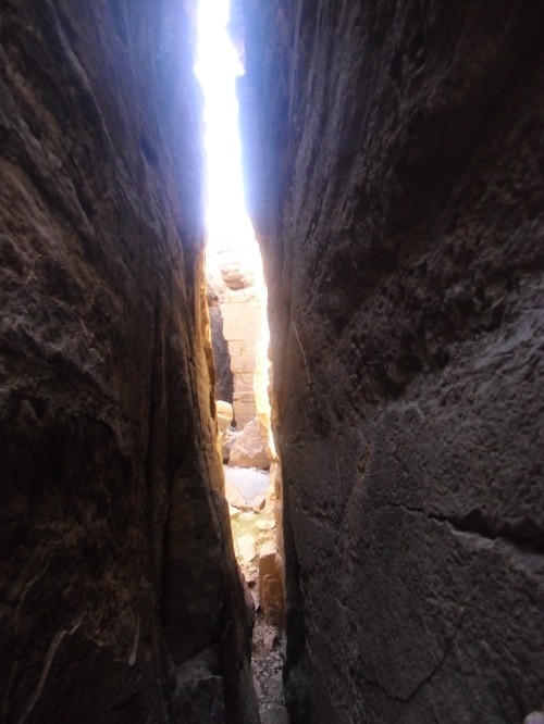
This is an area that we used to call “The Cracks” when I was growing up, but I don’t know if locals would know it by that name or if that was just something that we made up.
This would be a very scenic place to camp, as you are right on the edge of the Virgin river gorge and have views of Zion on one side and Pine Valley mountain on the other.
The big attraction here are the deep, narrow cracks that form a maze and are a lot of fun to explore from within and from above. From inside the cracks you can explore the labyrinth and from above you can step right across a 50 foot drop without hardly noticing that it’s there.
Unfortunately this has been used by careless partiers and there is a fair amount of trash at this site. It is just under 4 miles from the starting line. You’ll want to turn south on the dirt road between the BLM sign and an old wooden cattle pen and follow it for about a mile to the canyon’s edge. Here is the GMAP link. Zoom in and notice the fractures in the earth’s surface near the end point. Pretty amazing. The GPS coordinates are: 37°11’55.45″N 113°14’17.03″W
The next place that I’d recommend is about 5 miles up Kolob Terrace Rd. (aka Kolob Reservoir Rd.) next to North Creek. This would be an ideal group campsite for the race as it is not well known and doesn’t see a lot of use by other groups. We will have a port-a-potty there since it is on the 100 mile course and can be used by runners.
You’ll know you’re in the right spot if you see this sign. This is where you’ll park.
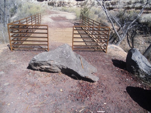
You’ll walk across a footbridge and cattle guard and after about 100 yards this is what you’ll see:
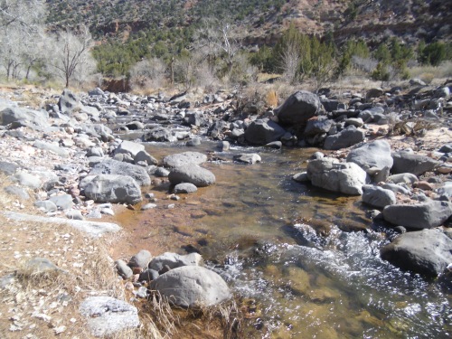
Right next to the creek and a nice swimming hole.
Here is a GMAP link to show how to get here. The GPS coordinates are: 37°15’7.84″N 113° 8’10.03″W
There is also this very popular “free” camping area closer to the starting line, but it sees a lot of people and is getting overused and trashed and doesn’t have any bathroom facilities. If you choose to camp here, ignore this sign:
Whoever made this sign is not the owner of the land and donations will not go to the landowner. It is on private property, but the town of Virgin, the county recorder, and the owner of the adjacent land don’t have current contact information or know how to get in touch with the owner. This camping area is straight across from where the 100 milers will leave the paved road along Kolob Terrace Rd. and begin crossing the Virgin desert. It’s about 2.5 miles from the starting line.
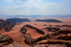
There are plenty of beautiful camping spots (such as the image above) along Smith Mesa road, within 10-15 min. of the starting line. Please don’t camp farther than 5 miles into Smith Mesa road (from the Kolob Terrace Rd. side) because after that you would begin to overlap with the section of road that runners will be using. Here is the GMAP link.
Below is one of my favorite campsites, but it can only be accessed with 4wd. It is surrounded by cliffs on both sides and has incredible views. You’ll take Smithsonian Butte Rd. from the Rockville side to get to this little gem. Here’s the GMAP link. And the GPS coordinates: 37° 8’30.31″N 113° 3’40.62″W
While there are many beautiful places to camp up on Gooseberry Mesa, we’d discourage camping there for two reasons. 1)Runners will be running along the access road to Gooseberry Mesa and we need to reduce traffic and dust, and 2)Proximity to the start/finish line. Even though you could drive to the edge of the mesa looking down on Virgin and be within a couple of miles from the starting line as the crow flies, it would take you about 45 minutes to drive to this point.












Thanks for the heads up. Is anyone out there looking to share a cabin and split the costs? I’d like to be in the area about a week or so early and would be open to an ultra roommate(s).
You might try posting on Facebook as well
I would share a place… I am only going to be up there the night before however and the night after the race so Thursday night and Saturday night. I was thinking about just camping otherwise. Im driving my truck up from Scottsdale, AZ.
This is so cool that you took the time to report on free camping! There’s no question that I’ve signed up for the right event.
Can’t wait to be out there!!
We are renting an RV (25ft I think) and wondering if any of the free camping spots is appropriate for that?
You can park it at the free group campsite, there’s room there and you’ll have a portapotty and be near the river. The other place I’d recommend would be up on the edge of Gooseberry Mesa. Plenty of cool spots up there, it is just a bit of a drive to get there. Smith Mesa would also be cool. The road’s a little steep to get there and a bit rutty once it turns to dirt, but you’ll probably be OK unless it rains while you’re there. You’d want to stay off of Gooseberry if it rains to, the access gets really messy.
Thanks, we appreciate your helpfulness.
We’ve scouted out a few free places to park our rv since we’ve been in the area.
Dalton Wash is ok if you can get a spot. Not too far off the main road as well as not far from the cemetery. There’s a nice little trail that follows the little creek for a few miles. You can also drive over to the cemetery and do the short climb up Grafton Mesa for some sweet views.
Laverkin Overlook – we plan to spend a day or two here. Much too windy today though. Appears to be nice trails all around and the overlook view is pretty sweet. I believe this is near the above mentioned “The Cracks” area?
We also scouted out the above mentioned “Donation sign” area. There’s a few people camping here already but we found a sweet little spot that the Summit Seeker can get to that is right along the water. There appears to be a porta potty a short walk away as well. A pickup truck would have an easier time reaching some of these sites.
We’ve also spent a few nights at the Best Western parking lot to “borrow” wifi. Not recommended but can be done if you are subtle about it.
-Shacky
You should camp at the Smith Mesa aid station location one of these nights while you’re here. The views are unbeatable. You definitely need to drive (or run) Smith Mesa road while you’re here. Also, the Goosebump aid station would be an ideal camping spot on the edge of the mesa there, but you’d have a bit of a drive to get around to it from the Apple Valley side because the RV wouldn’t make it up Crybaby Hill.
What you described as Dalton Wash is actually “Horse Valley Wash”, where the Smithsonian Butte and Grafton roads meet. Dalton Wash is the access road to Guacamole trail.
Thank you for posting these great BLM spots with great detail. It’s been a while since I was out to Zion and headed there this weekend and my last camp spot has since closed. It was difficult to find what was still available-so thank you!